Chapter 2 Study case and model
2.1 The Seine River study case
In this study, we focus on the Seine basin, more specifically the area upstream of Vernon, which covers approximately 64,420 km² (Figure 2.1). The topography of the basin is generally flat, with an altitude gradient varying from 31 to 300 metres on average, with the exception of the Morvan region where altitudes can reach 901 metres. The hydrological regime of the Seine basin is influenced by an oceanic climate, resulting in higher flows from November to June and lower flows from July to October. While the impact of snow is generally limited, it becomes more significant during periods of heavy snowfall, particularly in the Morvan region. The surface area of this basin covers the main tributaries of the Seine, the Yonne (293 km), the Marne (525 km) and the Aube (248 km).
The Seine basin is subject to a number of anthropogenic influences. The basin has a high demand for water, but also very high pollution pressure, as it is home to around 18 million people, or 27% of the population of metropolitan France, including 12 million in the Île-de-France region alone.
Among the anthropogenic influences, we will limit ourselves to the four reservoir lakes located upstream in the basin, with a total volume of 807.5 Mm3. Built between 1949 and 1990, these reservoirs are managed by EPTB Seine Grands Lacs and have the dual purpose of reducing floods and supporting low-water levels.
EPTB Seine Grands Lacs acts at the level of the upstream basin of the Seine, facilitates and coordinates the public action of local authorities throughout the territory through its missions:
- Managing flood risk in the Seine basin by capping floods. -Supporting river flow during the dry season.
- Acting for the reduction of vulnerability to floods.
- Providing a role of advice, animation and coordination with the basin communities.
- Preserving the environment.
The UMR G-EAU was involved with the EPTB Seine Grands Lacs in the ClimAware project (ERA-NET IWRM-NET 2011-2013) on the Seine River study case. The objective of this study case was to provide an analysis framework to water managers for evaluating potential consequences of climate change on the river basin hydrology and assessing adaption strategies to cope with these changes. These adaption strategies were developed at tactical (adaption of target reservoir filling curves) and at operational (real-time reservoir management) levels.
Some project outputs were used by the EPTB Seine Grands Lacs such as :
- a flood and droughts risk assessment tools considering the filling of the reservoirs for any period during the year;
- the adaptation of the reservoir filling curves which has been presented at the Technical Coordinating Committee for Studies and Works and has been used to modify the shape of the reservoir filling curves.
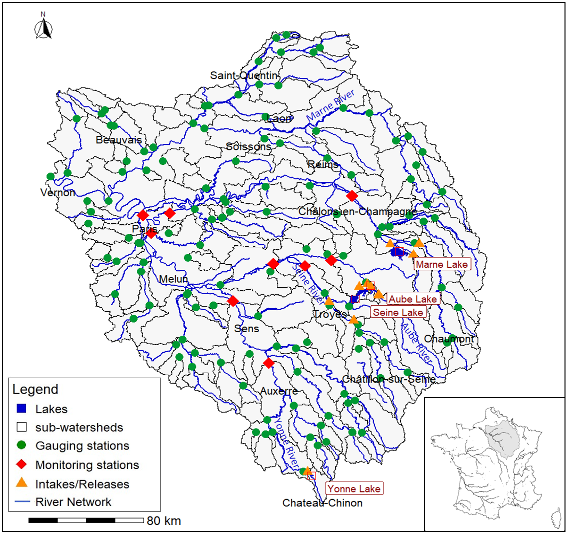
Figure 2.1: Study area of The Seine River Basin
2.2 airGR & airGRiwrm models
Studying the impact of climate change and adapting water resource management requires tools for modelling the rainfall-flow relationship and uses in spatial terms.
We perform the Seine River basin modelling thanks to the airGRiwrm R package (Dorchies, Delaigue, and Thirel 2022) based .
2.2.1 The airGR R-package: an R implementation of GR models
The airGR package (Coron et al. 2017) is a free package available in the R language that provides the GR family of rain-flow models, including GR4J (Perrin, Michel, and Andréassian 2003), and their latest developments. These empirical models, which operate on hourly, daily, monthly and annual time steps, use rainfall and air temperature data to simulate river flows (Perrin et al. 2018). The package also includes a snow accumulation and melting model, functions for optimising model parameters, assessing model performance and plotting analysis graphs.
For more informations: https://hydrogr.github.io/airGR/
In this study, we use the GR4J model (Perrin, Michel, and Andréassian 2003) which is a simple conceptual model with 4 parameters to be optimised (Figure 2.2). The model has been tested in a large number of studies over several years throughout France, particularly in operational research.
Two types of data are required as model input:
- Precipitation, corresponding in this case to daily rainfall totals;
- Potential evapotranspiration, which represents water loss in the catchment area under study.
The first part of the model, known as “interception”, corresponds to a production function used to determine the actual input of raw rainfall, which will be used to estimate the flow. The first free parameter is \(x_1\) (mm) corresponding to the maximum capacity of the production reservoir. \(S\) corresponds to the quantity of water in this reservoir at time \(t\). This reservoir takes rainfall and evapotranspiration into account. It can also take into account modules such as Cemaneige, which takes solid rainfall into account (Valéry 2010) and adds two new parameters to the model.
Then, the transfer function takes into account a unit hydrograph to distribute the slow (90%) and fast (10%) flows from the production function. Both hydrographs depend on the free parameter \(x_4\) (j). The slow flows fill a routing reservoir whose volume corresponds to the free parameter \(x_3\) (mm). \(R\) corresponds to the quantity of water in this reservoir at time \(t\).
A fourth free parameter, \(x_2\) (mm/d), corresponds to the loss/gain coefficient due to exchanges between basins at subsoil level.
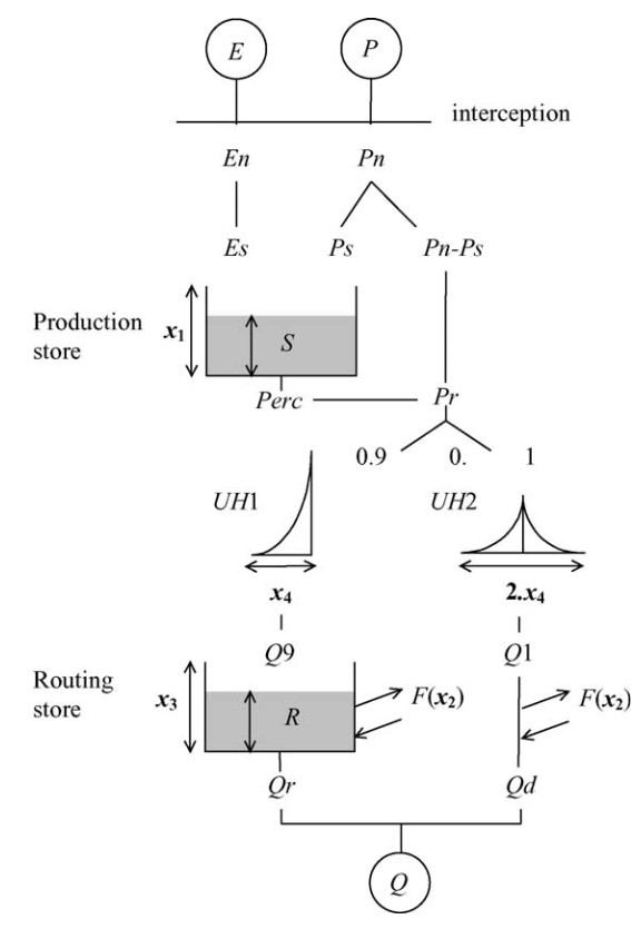
Figure 2.2: Functional scheme of the GR4J model
2.2.2 The airGRiwrm R-package
The airGRiwrm package is an R package that ‘encapsulates’ airGR, i.e. it uses its GR functionalities and models directly, but systematises their use in a semi-distributed way thanks to a set of new functions enabling a network of models to be set up (Dorchies, Delaigue, and Thirel 2022). In addition, airGRiwrm makes it possible to include water uses in this network, either by injecting measured water intakes or restitutions directly, or by allowing coupling to use models (Figure 2.3). In addition, as uses are subject to management rules or restrictions, it is possible to use ‘controllers’, which implement decision logic and determine, for example, when demand for a use is met or not.
For example, this package can be used to simulate the flows in catchment areas that include reservoirs for flood control or low-water support, canals for inter-basin transfers, and all kinds of abstractions and discharges and their regulation.
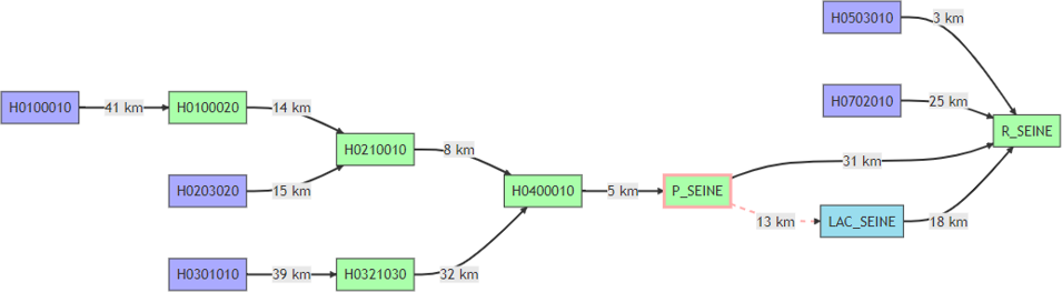
Figure 2.3: GRiwrm graph representing the vicinity of the Seine reservoir. In blue, upstream GR hydrological modelling; in green, GR hydrological modelling of intermediate catchment areas; in turquoise, reservoirs; in red, human diversions.
2.2.3 The seinebasin2 R-package
The work carried out for this study and the resulting reports were developed specifically for the project in the form of an R package called seinebasin2.
The seinebasin2 package is built as an extension of the airGRiwrm and airGR packages. The data are stored on a cloud, and can be automatically loaded with the script directly from the cloud, or copied locally and used locally.
The code below loads the cfg configuration, which contains the path to the data folder (by default from the cloud):
library(seinebasin2)
cfg <- loadConfig()
cfg$data$path
#> [1] "https://nextcloud.inrae.fr/s/adinzGa3AmLEXnZ/download?path="
Data can be downloaded from Nextcloud via this link: https://nextcloud.inrae.fr/s/adinzGa3AmLEXnZ.
See the documentation of the functions loadConfig and getDataPath of the
seinebasin2 package for more details on data management: https://in-wop.g-eau.fr/seinebasin2